[ad_1]
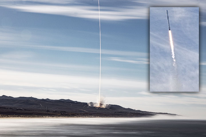
A joint US-Europe satellite, built to monitor global sea levels, took off on a SpaceX Falcon 9 rocket from Vandenberg Air Force Base just after 9:00 am Pacific time on November 21, 2020. About the size of a small pickup truck , Sentinel-6 Michael Freilich will extend a nearly 30-year continuous dataset of sea surface height.
The satellite’s primary instrument is a radar altimeter, which monitors the height and shape of the ocean’s peaks and valleys, known to scientists as ocean surface topography. Radar altimeters continuously send pulses of radio waves (microwaves) that bounce off the surface of the ocean and reflect back to the satellite. The instrument calculates the time required for the signal to return, also monitoring the precise position of the satellite in space. From this, scientists can derive the height of the sea surface directly below the satellite.
Sentinel-6 Michael Freilich will continue a sea level record that began in 1992 with the TOPEX / Poseidon satellite and continued with Jason-1 (2001), OSTM / Jason-2 (2008) and Jason-3 (2016). Together, these satellites have provided precise, long-term measurements of sea level height, tracking how quickly our oceans are rising in response to global warming. Sentinel-6 Michael Freilich will pass the baton to his twin, Sentinel-6B, scheduled for launch in 2025.
“Together, these satellites will allow us to continue measuring global sea levels for another full decade,” said Josh Willis, NASA project scientist for the mission and ocean scientist at NASA’s Jet Propulsion Laboratory. “This is the first time that we are able to launch one while its predecessor is still young. Jason-3 is still in its design life, and that’s a big deal for us because to keep the accurate record when it’s passed from satellite to satellite, we really need them to overlap so we can cross-calibrate. “
The time-lapse video above shows the Falcon 9 exhaust plume in the 25 minutes following the rocket launch from California. Images were acquired with Advanced Baseline Imager (2 / red band) on GOES-17. The satellite is operated by the National Oceanic and Atmospheric Administration (NOAA) and NASA helps develop and launch the GOES series.
The probe is named in honor of Michael Freilich, the former director of NASA’s Division of Earth Sciences and a leader in advancing ocean observations from space. Freilich retired in 2019 and passed away on August 5, 2020. His family and close friends attended the launch of the satellite that now bears his name.
“Michael was a tireless force in the earth sciences. Climate change and sea level rise know no national boundaries and has supported international collaboration to address the challenge, “said Josef Aschbacher, Director of Earth Observation Programs for the European Space Agency (ESA).” It is fitting that a satellite in its name continues the ‘gold standard’ of sea level measurements for the next half-decade. “
“The Earth is changing and this satellite will help us deepen our understanding of how,” said Karen St. Germain, director of NASA’s Division of Earth Sciences. “Earth’s changing processes are affecting sea level globally, but the impact on local communities varies greatly. International collaboration is essential both to understand these changes and to inform coastal communities around the world. “
After arriving in orbit, the spacecraft separated from the rocket’s second stage and deployed its twin sets of solar panels. Ground controllers successfully acquired the satellite signal, and initial telemetry reports showed the spacecraft to be in good health. Sentinel-6 Michael Freilich will now undergo a series of exhaustive checks and calibrations before starting to collect scientific data in a few months.
Sentinel-6 Michael Freilich’s initial orbit is approximately 20 kilometers (12 miles) less than its final operational orbit of 1,336 kilometers (830 miles). In about a month, the satellite will receive commands to increase its orbit, dragging Jason-3 about 30 seconds. The mission’s scientists and engineers will then spend about a year cross-calibrating the data collected by the two satellites. Sentinel-6 Michael Freilich will then assume the role of primary satellite at sea level and Jason-3 will provide a support role until the end of his mission. The scientific instruments on both satellites will also make atmospheric measurements that can be used to complement climate models and help meteorologists make better weather forecasts.
Sentinel-6 Michael Freilich and Sentinel-6B make up the Sentinel-6 / Jason-CS (Continuity of Service) mission developed in collaboration with ESA, NASA and NOAA. NASA JPL is contributing three scientific instruments to each Sentinel-6 satellite: the Advanced Microwave Radiometer for Climate, the Global Navigation Satellite System – Radio Occultation and the Laser Retroreflector Array. NASA also provides launch services, ground systems and data support and support for the US component of the international ocean topographic science team.
To learn more about the sea surface height and the long international collaboration to study it, read Taking a Measure of Sea Level Rise: Ocean Altimetry.
To learn more about Sentinel-6 Michael Freilich, visit the mission home pages at the European Space Agency, NASA, the European Union’s Copernicus program and EUMETSAT.
Are you looking for data related to sea level rise? The Sea Level Change Data Pathfinder on NASA’s Earthdata site highlights the tools researchers used to study ocean altimetry, including integrated multi-mission ocean altimeter data for climate research.
NASA Earth Observatory video by Joshua Stevens, using GOES 17 data from NOAA and the National Centers for Environmental Information (NCEI). Photographs courtesy of SpaceX. Story collected from NASA and ESA press releases by Mike Carlowicz.
Source link
